|
News  2011 2011  GAP for the 2011 Sendai Tsunami/Earthquake Emergency GAP for the 2011 Sendai Tsunami/Earthquake Emergency

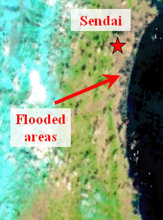
Flooding from tsunami (Japan, March 11, 2011)
Data Source: MODIS
Last Update: April 08, 2011
In the framework of the GEO Geohazards Supersite initiative,
GAP srl performed an assessment of the areas of flooding from tsunami near Sendai (Japan) by processing remote sensing data provided by MODIS on the Terra satellite.
False-color (RGB) images have been generated from the following MODIS products:
MOD021KM – Level 1B Calibrated Radiances – 1KM
MOD02HKM - Level 1B Calibrated Radiances – 500M
MOD02QKM - Level 1B Calibrated Radiances – 250M
MOD03 – Geolocation – 1KM
Processed products consist in the proper composition of bands 1-2 (250 m resolution) and band 7 (500 m resolution).
Final results are available here.
Credit: Khalid Tijani, Alberto Morea

InSAR co-seismic ground displacement monitoring in the areas stricken by the Mw=9.0, March 11, 2011 Sendai/Tohoku-oki Earthquake
Data Source: ENVISAT
Last Update: March 22, 2011
In the framework of the GEO Geohazards Supersite initiative,
GAP srl and Politecnico Bari contribute by generating co-seismic interferograms over the areas stricken by the Sendai/Tohoku-oki mainshock.
Differential interferograms are generated through the SPINUA © processing chain.
Credit: Davide Oscar Nitti
|
TRACK: 347
|
PASS: DESCENDING
|
GROUND COVERAGE
|
|
Pre-seismic Acquisitions
|
Post-seismic Acquisitions
|
Co-seismic interferometric phase pattern
|
|
February 19, 2011
1
2
3
4
5
6
7
8 -
ALL
|
March 21, 2011
1
2
3
4
5
6
7
8 -
ALL
|
February 19 - March 21, 2011
Before orbital artefacts removal
1
2
3
4
5
6
7
8 -
ALL
After orbital artefacts removal
ALL
|
|
TRACK: 74
|
PASS: DESCENDING
|
GROUND COVERAGE
|
|
Pre-seismic Acquisitions
|
Post-seismic Acquisitions
|
Co-seismic interferometric phase pattern
|
|
March 2, 2011
|
-
|
-
|
|
TRACK: 139
|
PASS: ASCENDING
|
GROUND COVERAGE
|
|
Pre-seismic Acquisitions
|
Post-seismic Acquisitions
|
Co-seismic interferometric phase pattern
|
|
March 6, 2011
|
-
|
-
|
|