|
High resolution images obtained by COSMO/SkyMED and TerraSAR-X new radar systems can be used to determine high precision DEM connecting the information from interferometric fringes with that obtained from persistent scatterers.
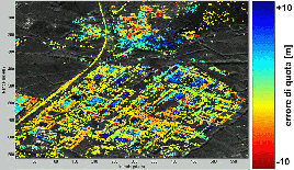
High precision height information estimated for persistent scatterers detected near Bazzano (AQ, Italy) by processing a dataset of COSMO/SkyMED stripmap images

|
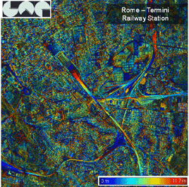

In the above figure, colours represent the interferometric phase connected with the height of the buildings and showing the slope of the roads. The interferogram has been obtained using two COSMO/SkyMED spotlight images.
|

